
Tags
Alaknanda river, Badrinath, Chamoli, Char Dham Yatra, Dhauliganga river, earthquakes, Garhwal Himalayas, Himalayas, Hydropower, Joshimath, land subsidence, landslides, Uttarakhand, Vishnu Prayag
A warm “Hello” and “Welcome to Swarupa’s World” 🙂 My world and the enchanting place with over 200 interesting reads providing countless thoughts to ponder over 🙂 Well, my posts are written with that objective in mind 😉
If you are my first-time reader, you might want to check out the entire list of my blog content in my post “List of All My Posts” or browse through specific content pages at the top or check out my four books 🙂 All of it and more here…you just have to move your eyes around my site and get it 🙂 Happy reading!
Today’s post is related to my travels in the Garhwal Himalayan region of Uttarakhand, India, some three months ago. It is about a picturesquely-located gateway of religious, cultural, tourist and strategic importance… and more! Joshimath 🙂
In this first part of “Why is my Joshimath sinking?”, I have presented the facts of the widespread land subsidence crisis that hit the town in January 2023, which had been predicted since the past many decades. It also covers reasons for the instability crisis as reported by eight premier scientific institutions of the country after their detailed study and investigation.
The second part of “Why is my Joshimath sinking?” is about my views and opinions on the land subsidence problem…and it’s going to be huge and sensational 🙂 So stay tuned 🙂
Related posts:
Discovering Sacred Hindu places in India –II: Rishikesh, Joshimath and Badrinath Dham and Mana
Discovering Sacred Hindu places in India –III : Kedarnath Dham and Haridwar
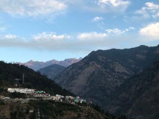
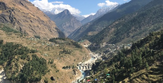
Situated at an elevation of 6,200 feet (1,890 metres), Joshimath is a scenic ancient town surrounded by tall and towering mountains of the Garhwal Himalaya in the mountainous Chamoli district of Uttarakhand, India.
It lies on National Highway 7 or NH-7 (formerly NH-58) which passes through the state capital Dehradun (290 km from Joshimath) and ends at Mana, close to the India-Tibet (China) Line of Action. The nearest airport is 265 km away, Jolly Grant Airport near Dehradun. The nearest railway station is Rishikesh, 250 km away.
![]()
Image credit: GSI
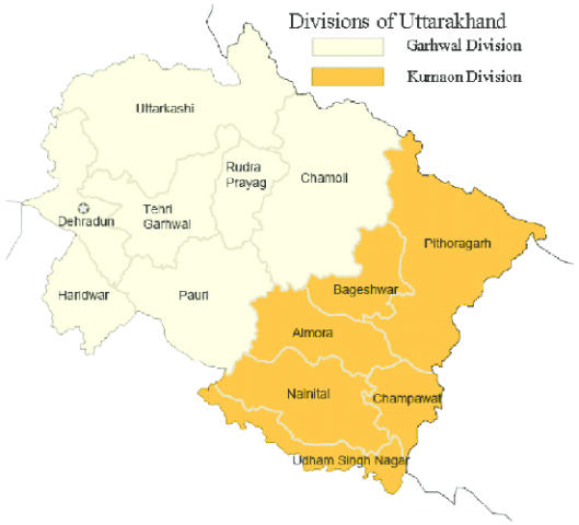
Famous for its noted temples and heavenly destinations, the Himalayan state of Uttarakhand (also called Dev Bhoomi “Land of the Gods”) was created in November 2000 from the hilly portions of the country’s most populous state, Uttar Pradesh. It was initially called Uttaranchal, but changed its name in January 2007.
Uttarakhand is divided into two regions: Garhwal and Kumaon. Chamoli is one of its picturesque districts in the Garhwal region.
The northern and eastern parts of Chamoli are covered by tall and magnificent mountain peaks such as Nanda Devi, Kamet, Mana, Trishul, Chaukhamba, Dunagiri, Nandakot, Neelkanth, Hathi Parvat, Nar Parvat and Narayan Parvat.
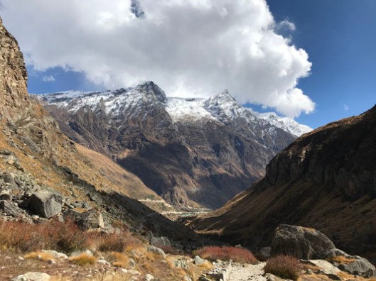
The mountain slopes are covered with glaciers which give rise to rivers such as Alaknanda, Saraswati, Dhauliganga, Birhiganga, Rishiganga, Kali, Pindar and Nandakini.
It is a glaciated terrain with highly rugged mountainous topography in the form of sharp, angular, and serrated ridges, narrow spurs, and valleys with steep slopes. Rivers and streams carry and deposit moraines (rock debris deposited by glaciers) in the valleys.
Draining an area of 12,173 sq. km, Alaknanda, is Chamoli’s main river with a length of 195 km. It originates from the Satopanth-Bhagirathi-Kharak group of glaciers in the Garhwal Himalayas and merges with Dhauliganga, Patalganga, Nandakini, Mandakini, and Pindar on its way downwards to Devprayag, where it merges with the Bhagirathi to form the holy Ganga, which flows into the plains and finally empties into the Bay of Bengal.
Chamoli has fragile geo-tectonic orogeny and comes under an eco-sensitive glacial system of Nanda Devi. A major Himalayan geological fault, the Main Central Thrust (MCT) passes through the region, owing to which it is placed in the country’s highest seismic zone, prone to deadly earthquakes. So it is vulnerable to natural hazards like earthquakes, landslides, avalanches, Glacial Lake Outburst Flood (GLOF), Landslide Lake Outburst Floods (LLOF), cloud bursts, flash floods, debris flow, etc.
In recent times, disasters have been of frequent occurrence due to changing climate and its impact on high gradient rivers and streams. Chamoli, and Uttarakhand in general, are facing intense development pressure from tourism, rapid urbanization and hydropower development.
Hydropower in Uttarakhand…
Uttarakhand is nestled in the ecologically fragile and earthquake-prone Himalayan region, but it has unleashed rapid development, much of it driven by hundreds of run-of-river hydropower projects, which use the natural download flow of rivers and micro turbine generators to capture the kinetic energy carried by water.
In run-of-river systems, river water is diverted by a weir through an opening in the river side (the ‘intake’) into a channel.
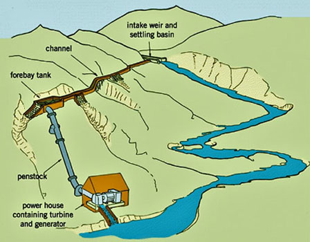
A settling basin is built in to the channel to remove sand and silt from the water. The channel follows the contour of the area so as to preserve the elevation of the diverted water. The channel directs the water into a small reservoir/tank known as the ‘forebay’ from where it is directed on to the turbines through a closed pipe known as the ‘penstock’.
The penstock essentially directs the water in a uniform stream to the turbine at a lower level. The turning shaft of the turbine can be used to rotate a mechanical device (such as a grinding mill, oil expeller, or wood lathe), or to operate an electricity generator.
When electricity is generated, the ‘power house’ where the generator is located, transfers the electricity to a step-up ‘transformer’ which is then transmitted to the grid sub-station or to the village/area where this electricity is to be used. Once electricity is produced, the water flow is returned back to the river.
The power is generated only when enough water is available from the river/stream. When the stream/river flow reduces below the design flow value, the generation ceases, as the water does not flow through the intake structure into the turbines.
Hydropower has for long been a subject of controversy in Uttarakhand, which has great potential for hydropower development because of its mountainous environment and turbulent rivers.
In the initial years of Uttarakhand’s statehood, only a small part of its estimated hydropower potential was harnessed. The state suffered from power shortage, which restricted economic productivity. Realizing its full power potential became a state priority, especially because export of power to other states would form a major source of revenue. Furthermore, Uttarakhand has a responsibility to contribute to a national objective to achieve energy balance between hydro and non- hydro sources.
While the turbulent Himalayan rivers are excellent for hydropower generation, and growth in the hydro sector could improve economic and social well-being in the state, the strain and pressure that construction work puts on the fragile ecosystem can have multifarious impacts.
Hence assessment of the total impact of the construction of each project and its implication on ecology, environment, geology and underground hydrology is of utmost importance.
Catastrophic events in Uttarakhand…
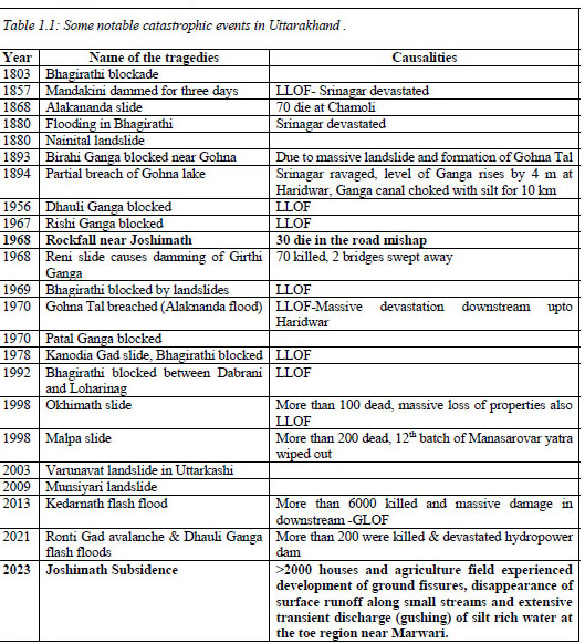
Source: NGRI
The 1991 Uttarkashi earthquake of 6.8 magnitude hit the undivided state of then Uttar Pradesh (now Uttarakhand) killing at least 768 people. It was followed by the 1999 Chamoli earthquake measuring 6.8 on the Richter scale, which killed over 100 people.
The history of natural disasters and their consequences in Uttarakhand with particular reference to Joshimath in Chamoli district has posed a challenge as it lies in the country’s highest seismic zone and is exposed to various natural hazards including earthquakes, landslides and flash floods.
In Chamoli, there are many operational dams and hydropower projects of varying sizes in the Alaknanda basin, and still more of them have been planned and are under construction.
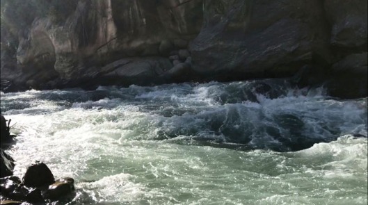
Several streams drain into the Alaknanda and Dhauliganga rivers. These streams are known for the devastation they have caused in the past, when flash floods followed the blockade of these streams owing to landslides and infrastructure projects.
The topography of Chamoli being of high mountains and deep gorges, rivers generally flow with great force through the steep and narrow channels, often resulting in excessive erosion and collapse of the embankments.
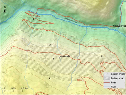
Image credit: NGRI
Alaknanada and Dhauliganga rivers meet at Vishnuprayag, which lies just below Joshimath.
In June 2013, Uttarakhand was devastated by a multi-day cloudburst that triggered floods and landslides. In Chamoli, it caused a flash flood in the Alaknanda catchment which resulted in a huge loss to life and economy.
In February 2021, Joshimath was hit by a devastating flood caused by a massive rock and ice avalanche, which nearly washing away two hydropower projects located downstream from Rishiganga river – the 13.2 MW Rishiganga project at Raini village and the 520 MW Tapovan-Vishnugad project.
The disaster happened when an enormous chunk of rock ice in the Nanda Devi range broke off, resulting in an unprecedented level of debris flow at an extremely high speed in the narrow Raunthi Gadhera, Rishiganga, and Dhauliganga river valley near Joshimath. It resulted in a burst of water rushing violently, roaring down the narrow Dhauliganga valley, leaving a trail of destruction in its wake.
One of two tunnels connected to the Tapovan-Vishnugad hydro power project was blocked after the huge flood in which more than 200 people were killed and missing.
Here’s a video of that moment when the construction site of the Tapovan-Vishnugad project came crashing down with the powerful force of Dhauliganga.
https://x.com/swarupa007/status/1734655469476835741?s=20
JOSHIMATH
One of the 12 tehsils (sub-districts) in Chamoli district, Joshimath is built on a north-dipping upper-middle slopes of a hill alongside which flow the high gradient Alaknanda and Dhauliganga.
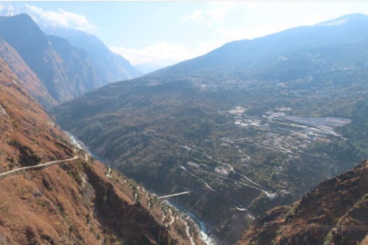
Image credit: GSI
The town’s elevation varies from 1332 m to 3229 m with a maximum elevation near Auli and a minimum at the Alaknanda river bank.
![]()
Image credit: NDMA
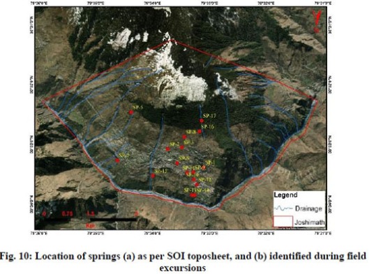
The town sits on an E-W running ridge to the SW of Vishnuprayag, the confluence of Dhauliganga and Alaknanda. During winter, the upper reaches experience appreciable snow because of which groundwater is recharged, keeping the springs and streams around Joshimath perennial.
Perennial springs & streams flowing down from the hill’s upper reaches…
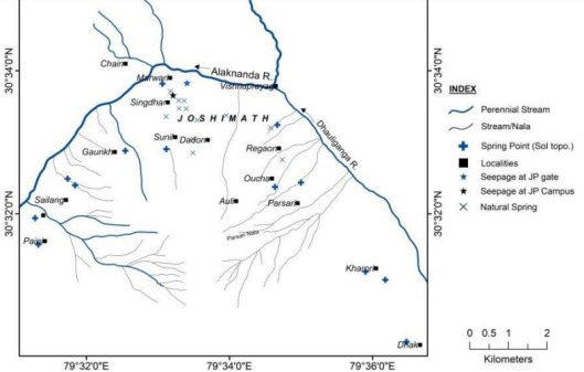
Image credit: GSI
Joshimath lies to the south of the Greater (or Higher) Himalayan zone – the backbone of the tall and mighty Himalayas. This is where the Indian Plate is pushing under the Asian (or Eurasian) Plate, since their collision around 50 million years ago. The Greater Himalaya zone is largely made of crystalline rocks and is the largest crystalline unit representing the mid-crust in the Himalayas.
‘Crystalline’ refers to an igneous or metamorphic rock, in which minerals were crystallized in the rock itself; unlike a sedimentary rock which contains minerals derived from other rocks.
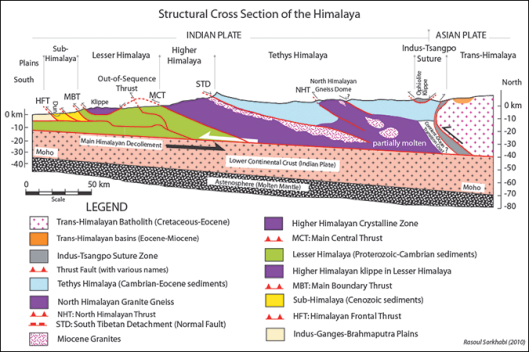
The Main Central Thrust (MCT) is a major fault running along the 2500 km Himalayan belt. It is responsible for the uplift of the Higher Himalayas, and runs in a northwest-southeast direction, separating the high-grade metamorphic rocks of the Higher Himalayan Crystalline Belt from the low-grade metamorphic rocks belonging to the Lesser Himalayan Belt in the south.
Joshimath is situated over the Higher Himalayan Crystalline Rocks, which are primarily high-grade gneisses and schists. These crystalline rocks are well exposed in the Alaknanda valley. They are thrust over the meta-sedimentary rocks of the Lesser Himalayan along the MCT, which passes beneath Helang, a small town about 7 km south of Joshimath.
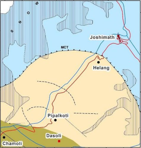
Image credit: CGWB
Owing to close proximity to the MCT and two other geological faults, the Joshimath area is highly vulnerable to any tectonic activity on the fault lines, which is why it falls under India’s highest seismic zone V with the highest risk of damaging earthquakes measuring over 7 in magnitude.
Joshimath has ancient connection to the 2500-year-old Adi Shankara traditions. Renowned 5th-century BC Hindu saint and philosopher Adi Shankaracharya attained enlightenment in this town. He named the place as Jyotir Math. (“Monastery of Light”) and went on to establish the original Char Dham (four religious abodes) – Badrinath, Rameshwaram, Dwarka and Puri – and four Maths (monasteries) in the four cardinal directions of India.
Location of Narsingh temple…
![]()
Image credit: GSI
Narsingh Temple and Jyotir Math formed the religious and cultural centres around which Joshimath town has grown and developed.
The town is a transit point for Hindu and Sikh pilgrims visiting the holy shrines of Badrinath and Hemkund Sahib. It also serves as a base for treks and mountaineering expeditions and to nearby tourist areas such as Auli, the country’s popular ski resort, and the Valley of Flowers National Park, which is a UNESCO World Heritage site.
It is also of strategic significance to the Indian armed forces and is home to one of the Army’s most important cantonments as the Line of Actual Control (LAC) with China is less than 150 kilometres away. Mana Pass in the Mana Valley and Niti Pass in the Niti Valley, the two ancient passes and trade routes along the LAC connecting India and Tibet, are accessed through Joshimath.
Joshimath town is divided into nine wards: Gandhinagar, Marwari (or Pekamarwadi), Singdhar, Manohar Bagh, Upper Bazar, Lower Bazar, Sunil, Parsari, and Ravigram.
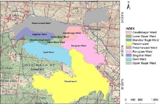 Image credit: GSI
As per the district administration, the estimated population of Joshimath in 2023 was 23,395.
As per the Census 2011, the literacy rate of Joshimath is 91.3%. The male literacy rate is 95.2% and the female literacy rate is 85.2%.
The economy of Joshimath is primarily based on tourism. Sustenance agriculture and animal husbandry are also common. Agriculture and trade was the primary livelihood until the 1990’s when the town gained popularity as a tourist destination. This resulted in the local population taking up businesses related to the tourism sector. It also led to the rapid conversion of agricultural land into hotels, home stays, restaurants, and other tourist facilities.
Despite its small size, the town is connected to the rest of the region by a network of roads, and there are regular bus and taxi services to nearby towns and cities. It also has a small hospital and several medical clinics.
A number of hydroelectric power projects are also being built around Joshimath town. Roads have been laid and tunnels bored to improve connectivity and build infrastructure.
The big hydropower projects in the immediate vicinity of Joshimath include the 400-megawatt Vishnuprayag Hydro Electric Project (operating), the 520 MW Tapovan Vishnugad Hydropower Plant (under construction, but now halted), and the World Bank-funded 444 MW Vishnugad-Pipalkoti Hydro Electric Project (under construction).
Tapovan is located on the banks of Dhauliganga, which originates in the vicinity of Niti Pass. The river joins Rishiganga at Raini village, close to Tapovan.
The February 2021 floodwaters caused major damage to two hydroelectric power plants located downstream from the Rishiganga River – the NTPC Tapovan-Vishnugad project, which was under construction when the disaster hit, and the Rishiganga project, which had resumed generating power the previous year after being damaged in the 2016 floods.
The Rishiganga power project at Raini was the first to face the brunt of the disaster. The debris from this plant damaged other units downstream and endangered the lives of the people working there.
While the flash flood was caused by natural reasons, the presence of hydro projects and other manmade constructions led to most human casualties and financial losses. Experts had been raising alarm bells about the structural safety of the projects since the beginning, but these warnings were brushed aside by the developers and government agencies.
The Rishganga project development was done with blasting work, excessive mining and tree felling. The resulting muck was dumped close to river, making the area disaster prone during flash floods.
The Tapovan-Vishnugad project led by National Thermal Power Corporation Ltd (NTPC) has been mired in controversy since the very beginning. The head race tunnel of the project traverses all through the geologically fragile area below Joshimath. Despite public opposition to the project owing to the geological and environmental vulnerability of the region, construction work began in November 2006. It courted controversies in 2009, 2012, 2014 and 2021.
In December 2009, a tunnel boring machine (TBM) employed for excavating the head race tunnel got stuck while digging the hilly terrain at a depth of 900m. It punctured a water-bearing strata some 3 km inward the left bank of Alaknanda near Shelong village (This village, close to the tunnel, has been facing cracks and land subsidence), leading to massive flow of subsurface water containing faulted rock materials. The water discharge was reportedly between 700 and 800 litres per second. The aquifer discharge was about 60–70 million litres daily, enough to sustain 2–3 million people. Even after a month, the aquifer had not dried out. At that time, the work was “put on hold for almost 10 months.
The seriousness of the matter prompted geologists MPS Bisht and Piyoosh Rautela to write this article in 2010: Disaster looms large over Joshimath
The paper predicted land subsidence in the future due to “dewatering” of the area.
In 2012, a TBM was trapped in the same 20m-wide fault zone. In 2014, along with the state’s other hydropower projects, the Tapovan-Vishnugad project too came under the Supreme Court scanner. The project became controversial again in January 2023, when widespread land subsidence occurred in and around Joshimath.
Read: Tapovan Vishnugad HPP: delays, damages and destructions
Past studies of land subsidence in Joshimath
According to a 2011 study, the North-Western Himalaya witnessed around 51 % of all the landslides in India during the years 1800 to 2011.
Land subsidence in Joshimath has been going on since the 1960s. The first warning of the town’s fragile ecosystem was given way back in 1886 by Edwin T. Atkinson, who wrote in The Himalayan Gazetteer that the town was located on landslide debris.
In 1974-75, N.C Agarwal and S. K. Mukhopadhyay carried out geological and geomorphological studies of the Joshimath-Badrinath area and stated that Joshimath is situated on a slope of semi-consolidated scree material strewn with large gneissic boulders, which are seen in different parts of the area. According to them, probably, a large volume of rocks and loose material slides over the foliation planes of schists and gneisses due to instability of slope, caused mainly by lateral cutting of Alaknanda and Dhauliganga rivers.
In 1976, reports of ground sinking led to the formation of the Mishra Committee to investigate the cause of instability and suggest relevant remedial measures. The committee reported that the town was situated on an old landslide zone and was sinking. It warned of the limited load-bearing capacity of slopes and recommended a ban on heavy construction work in the area. It also pointed that inadequate drainage facilities were causing landslides. “Joshimath is not suitable for a township”. But the warning went unheeded.
Now, after almost five decades, following increased anthropogenic pressure and climate change, Joshimath has become extremely vulnerable and susceptible to major land deformation.
Anthropogenic pressure…
Being the gateway to Badrinath and Hemkund Sahib pilgrimage, the town receives around 25,000 footfalls per day during the peak season between April-October. The peak months for winter tourism are December and January. In 2022, the annual footfall was close to 850,000.
The growing numbers resulted in a heavy build-up of tourist infrastructure in a small-town area of 11.49 sq km. Several multi-storey buildings came up too. Many new buildings came up on the landslide prone zone by erecting retaining walls, resulting in increased pressure on the already fragile slope.
Joshimath suffers from lack of proper drainage and sewer management. Waste water seeps into soil loosening it from within causing internal erosion. Water seepage reduces the shear strength of the overburden soil, which induces landslides.
Waste discharge from hotels, homes, etc. increases with rising number of tourist footfalls. Subsurface drainage is also caused by rainwater and melting of ice. Furthermore, unplanned and unauthorized constructions block natural drainage systems, forcing water to seek out alternate drainage pathways.
Climate pressure..
Heavy and incessant rains and snow melt pose a serious risk as rapid water flow from the hill causes widening of massive cracks and fractures in the sub-surface rocks. They also cause mountain streams to expand their channels and change course, inducing further slope instability.
Being in a high intensity seismic zone prone to earthquakes, repeated tectonic activities make the rocks porous and water permeable. Gradual weathering and water percolation reduces the cohesive strength of the rocks over time, resulting in landslides.
Undercutting by rivers also result in landslides. The rapid current washes away debris and thus, start cutting the edges of mountains and uninhabited area.
As per Uttarakhand State Disaster Management Authority’s (USDMA) 2022 report, “Huge volume of debris-laden water brought down by the Dhauliganga during a previous flood event (February 2021) has also aggravated the toe erosion along the left bank of the Alaknanda, downstream of its confluence with the Dhauliganga river at Vishnuprayag. This adversely impacted the stability of the slope on which Joshimath town is situated.”
Flood events of June 2013 and February 2021 had an adverse impact on the landslide zone with toe erosion. It was further weakened during heavy rains in October 2021.
Widespread Land Subsidence 2023
In 2021, the Joshimath area experienced frequent landslides and flooding. That’s when the town reported cracks on walls of homes and buildings for the first time.
Then, in September 2022, the USDMA reported that several pockets of Joshimath were sinking gradually. It observed that land subsidence (a gradual settling or sudden sinking of land surface due to removal or displacement of subsurface materials) had induced structural defects and damage in almost all wards of the town. This became more evident in the final months of 2022.
Towards the end of December 2022, local residents started protesting when homes and buildings started developing cracks at an accelerated rate. Then, on January 2, 2023, a major catastrophe hit the town when muddy water suddenly started gushing out with great force from the free face of a terraced slope in JP colony campus in Marwari ward, the lowest portion of the town above the Alaknanda river.
It led to sudden spurt of ground subsidence in different wards of Joshimath, converting the town into a disaster zone.
Several ground fissures and cracks appeared in civil structures including residential buildings, roads, hotels, etc., especially in the town’s western part i.e. in Marwari, Sunil, Manohar Bagh and Singdhar wards.
![]()
Image credit: GSI
According to local residents, ground subsidence had been noticed over several years but it became increasingly severe from January 2 to January 8, 2023. Several households around Marwari ward and the upper stretches up to Sunil ward reported cracks in their buildings during the same time.
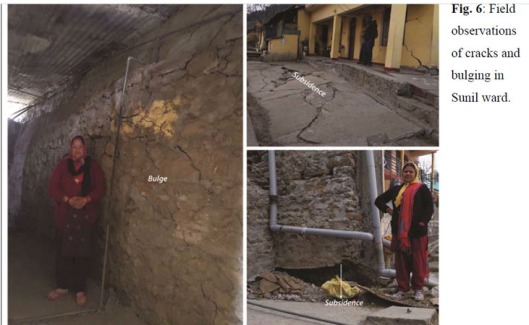
Image credit: NGRI
Damage to homes and infrastructure in April 2022 and January 2023…
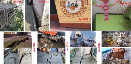
Image credit: ISRO
The oozing water was channelized into a drain, which was released at the road level. As per the data provided by the local administration, the initial discharge of silt-laden muddy water was 600 litres per minute on 02 January 2023, which was reduced to 200 litres per minute on 11 January 2023. The stored water got emptied by 01 February 2023, and in April 2023, appeared as a spring (discharge about 17 LPM) feed by a shallow subsurface channel.
Based on the discharge data provided by Jaypee Company (in whose campus the seepage occurred), a storage of 10.66 million litres is estimated to have got emptied in about one month. Roughly estimated, it would take 12 to 15 months’ time to store that much amount of water through new springs (discharge about 17 LPM).
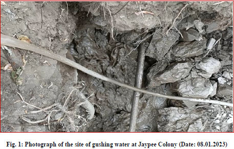
Image credit: NIH
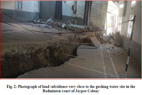
Image credit: NIH
The land subsidence carved a pattern (marked in purple points), with bottom from the slope toe near the seepage point in Marwari ward and and top near Sunil ward…
![]()
Image credit: NIH
Residents panicked as large, deep cracks emerged everywhere, snaking through floors, ceilings and walls of more than 500 houses, making them uninhabitable. Not just homes, they appeared everywhere around. Buildings, hotels, roads, agriculture fields, etc.
Houses and buildings became lopsided and had to be bulldozed. Roads and pavements developed fissures. Water seeped out of agricultural land.
Image credit : GSI
While many cases of land subsidence were reported in the past, the 2023 land subsidence was intense and distinct, hence it gathered widespread attention across the country.
The severe damage that generated cracks, and failure of foundations compelled the local administration to temporarily shift affected families to safer places. About 355 families were evacuated and temporarily relocated to hotels, while a few families sought shelter with relatives and temporarily migrated to other parts of the state.
The 4.15 km Joshimath-Auli ropeway, which connects Joshimath (at 6000 feet) with the skiing destination of Auli (at 9000 feet), was also affected by major subsidence near one of its towers. Established in 1994, the ropeway is considered one of Asia’s largest. It is not only a tourist attraction providing panoramic views of the snow-covered Himalayan landscape, but also a quick and easy mode of travel between the two places. It was shut down for public safety and has remained so till date.
Experts’ Studies
Following the land subsidence crisis, the government engaged top central, scientific and technical institutions to conduct independent studies and submit a detailed report outlining the cause of the problem and remedial measures to be undertaken.
The said institutions surveyed the subsidence area and conducted geological, geophysical, geotechnical, hydrological, remote sensing and ground deformation studies. The following eight reports were presented to the National Disaster Management Authority (NDMA):
- Safety Assessment of Buildings by Central Building Research Institute (CBRI)
- Hydrogeological Investigation Report on Land Subsidence by Central Ground Water Board (CGWB)
- Preliminary Report on Ground Subsidence by Geological Survey of India (GSI)
- Satellite based Deformation Analysis of Joshimath Town by Indian Institute of Remote Sensing (IIRS)
- Geotechnical Investigations for determining the Shear Strength Characteristics and Bearing Capacity of the Soil in the Joshimath Region by Indian Institute of Technology (IIT) Roorkee
- Geological & Geotechnical studies to understand shallow subsurface strata at Joshimath by National Geophysical Research Institute (NGRI)
- Identification of Source and Causes of Water Seepage in January 2023 by National Institute of Hydrology (NIH)
- Geophysical investigations to understand the sub-strata and seismic monitoring of the region by Wadia Institute of Himalayan Geology (WIHG)
Joshimath’s foundation…
All reports point at the town’s foundation of loose topsoil and soft rocks, which are less cohesive and susceptible to land subsidence. The slope over which Joshimath town is built is composed of thick loose soil derived from modified older landslide debris and glacio-fluvial deposit, which lies over the north-dipping basement Gneisses-Schist rocks of the Vaikrita Group.
As per GSI: “The slopes are covered with thick debris material comprising large rock boulders of granitic gneiss and schistose gneisses embedded in a matrix of fine micaceous sand, silt, and clayey material having low cohesion.”
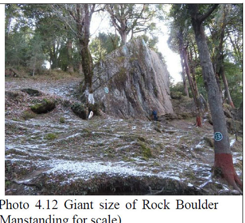
Image credit: GSI
NGRI added: “The Joshimath slope constitutes of disjointed patches of co-planar gentle slopes that are bordered by steep slopes producing series of benches. The gentle slopes have regolith cover of variable thickness. These gentle slopes are mostly occupied for habitation and subsistence agriculture.”
Medium to high grade metamorphic rocks of the Central Crystallines comprising of streaky and banded gneiss and schist are exposed at the base of Joshimath town, adjacent to the riverbed. The hillslope is constituted mainly of coarse-grained sandy gravel and large blocks and boulders of gneisses.
Groundwater saturation and land subsidence…
CGWB findings confirmed a zone of groundwater saturation in a linear pattern between Marwari, Singdhar, and Sunil Gaon, connected to a perched water body located within the thick overburden/debris material.
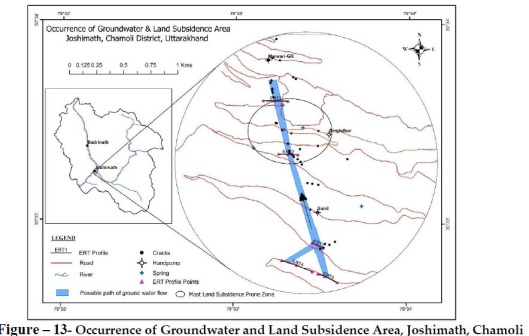
Image credit: CGWB
The same was aligned along the narrow linear zone trending NW-SE, where severe ground cracks and subsidence had occurred. GSI’s ground observation and NGRI’s Interferometric Synthetic Aperture Radar (InSAR) studies supports this inference.
GSI clarified that “the possibility of a single large-size deep detachment plane that can mobilize the entire hill mass between Auli and Marwari downward seems remote.”
Occurrence of a majority of recent ground cracks in a linear array between Marwari and Sunil wards prima-facie indicates that it is the result of a local phenomenon. The WNW – ESE / E – W trending ground cracks are following the contours which indicate some detachment planes which are confined in Manohar Bagh and Singdhar areas (and lying close to the ropeway alignment on the eastern side).
Cause of Water Seepage…
The cause of Marwari water seepage is still unknown, but according to NIH, the possibility of heavy rainfall (190 mm in 24 hours) that occurred in October 2021 (about 15 months before the start of gushing water) might be one of the prominent reasons for changing the soil/rock geomechanical and geotechnical properties that may have created an obstacle in the path of subsurface channels. In its 2022 report, USDMA had stated that the pace of land erosion had accelerated that year, with residents attributing this to heavy rainfall in October 2021 and catastrophic flash flooding earlier in the same year.
According to GSI, the burst of water is a clear indicator of built up of excessive pore water pressure back of the free face of the slope.
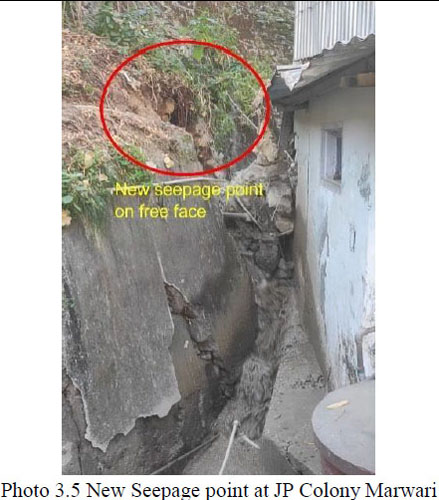
Image credit: GSI
The muddy colour of water indicates removal of finer matrix material from the old slide debris mass or an active regime of piping, which might have triggered an accelerated action of subsidence or failure.
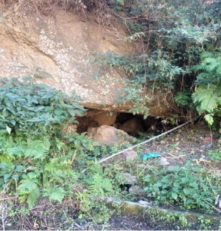
Image credit: GSI
The removal of finer material from the matrix or piping (by the shallow sub surface water flow lines or during the surface precipitation), in which the giant boulders are embedded, results in creation of hollows or void spaces beneath the giant boulders.
Growing removal of finer material over a long period of time results in vertical settlement of giant rock boulders under the influence of gravity. The settlement of such giant boulders causes a sagging on the surface, particularly when the settlement of boulders is happening close to the ground profile. This ultimately is reflected in the form of ground fissures or cracks, which in the initial stages may be very thin, but with the continued process, they may show progressive widening with time.
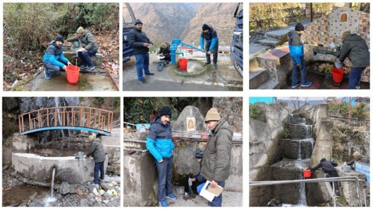
Disappearing streams…
NIH’s isotopic analysis suggest that the origin of the gush water in Marwari ward is from the upper reaches (Sunil forest and Auli area). The bacteriological analysis also suggested that the gush water is fresh water and not contaminated by the local drains.
The Western part of Joshimath has numerous springs which indicates good subsurface storage and transmitting capacities. Unfortunately, the topography (cascade of flat and steep terrain from top to bottom) and geological setting (presence of thick layers of galacio-fluvial and non-cohesive materials) of this part is in such a way which creates unfavourable condition for the development of permanent surface channels to dispose-off the water coming from upper reaches.
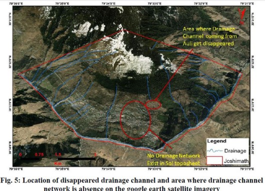
Image credit: NIH
This indicates that water coming from steep slopes get opportunity to infiltrate in this area due to change of slopes or soil material properties or both. Disappeared water may flow in the form of a subsurface channel, which either feeds the local springs or directly discharges to the river/streams as a base flow.
However, detailed resistivity survey can be helpful in capturing the moisture signature in the area to demark the path of subsurface channels.
Experts’ reports
GSI
Geological Survey of India (GSI) identified and mapped 81 ground cracks. Half of them were linked to the January 2023 subsidence, while the rest were older. Majority of the ground cracks, irrespective of their orientation, were located in areas of dense population and with many multi-storeyed buildings. Uninhabited or scantly populated areas remained unaffected by the subsidence.
It strongly advised carrying out ground-based terrestrial monitoring in different parts of Joshimath area to get a realistic and accurate assessment of ground movement, beyond the available results of Interferometric Synthetic Aperture Radar (InSAR), Differential Interferometric Synthetic Aperture Radar (DinSAR) and Continuously Observed Reference System (CORS) studies.
NIH
National Institute of Hydrology (NIH) mapped various springs, drainage networks and areas of subsidence, which inferred that land subsidence was connected with subsurface water.
Images credit: NIH
In its opinion, the top priority was safe disposal of the water coming from the upper reaches and of the town’s waste.
It also recommended regular monitoring of the town features with instrumentations and called for a need of controlled and regulated development system.eg. InSAR for monitoring and determining spatio-temporal land subsidence and compaction of underground aquifers, CORS and sharing of data with R& D organizations for modelling such subsidence in alarm system development.
“Natural water springs (act as natural piezometers) are good indicators for any change in the groundwater in the mountainous area.”
It also stressed the need to identify Himalayan towns having topographical locations and geological settings similar to Joshimath so that precautionary measures can be taken in advance.
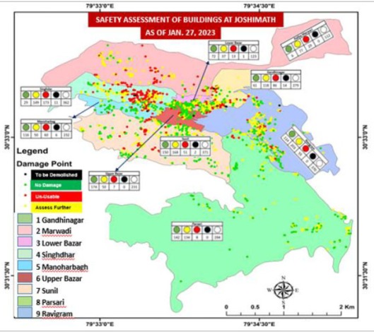
CBRI
According to Central Building Research Institute (CBRI), the significant pointers of ground settlement, could be geological i.e. presence of weak, fissured, sensitive, and unconsolidated material; geomorphologic i.e. steep and unstable slopes, kinematically unstable slopes, fluvial and glacial erosion; hydrology – drainage; and anthropogenic activities.
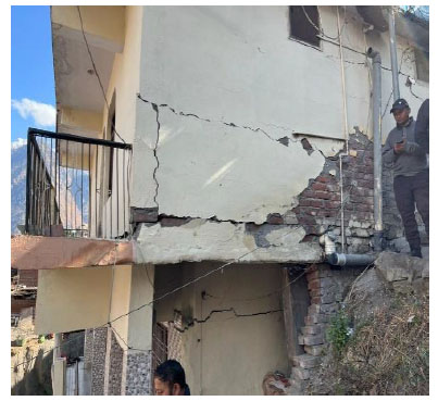
Image credit: CBRI
It conducted a detailed door-to-door safety assessment of 2,364 buildings (of which 2,152 were houses) spread over 2.8 sqm hilly terrain, in 9 administrative zones from January 14 to January 27, 2023.
![]()
Images credit: CBRI
Based on the assessment of magnitude of danger from subsidence, all the existing buildings were categorised under four heads;
- Black: Partly collapsed
- Red: Severely damaged, unfit for living
- Yellow: To be assessed further, needs major and medium level of retrofitting
- Green: Buildings without any damage, safe for living
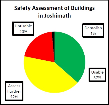
Image credit: CBRI
The town has 44% of masonry, 42% of RCC and 14% of other (traditional, hybrid) construction typologies, among which 99% are non-engineered i.e. not complying with the National Building Code of India 2016 provisions.
The number of stories of a building being an important attribute, 38%, 43%, 14%, and 5% comprised 1, 2, 3 and more than 4 floor buildings respectively.
.
IIRS/ISRO
Indian Institute of Remote Sensing (IIRS) / Indian Space Research Organization (ISRO) carried out space-based analysis of various datasets to understand the consistence slipping of the slope phenomenon. The area was analyzed using time series Satellite-based Radar Interferometry and complemented by Continuously Operating Reference Stations (CORS) to understand the direction and rate of movement.
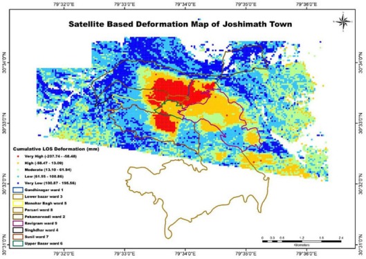
Image credit: IIRS/ISRO
Land deformation analysis of Joshimath was carried out using Differential SAR Interferometry (DInSAR) technique from Sentinel-1A imagery during the period from September 2022 to January 2023.
This image shows the deformation map (Gray scale) overlays on Pansharpened Cartsat-2E image (False Colour Composite) of Joshimath area…
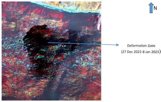
Image credit: IIRS/ISRO
The report concluded: “However, the satellite based observation needs to be supported by ground based observation and instrumentation. The subsidence in this region may be due to toe-cutting phenomenon, slope instability as a result of seepage of local drainage water in the soil, terrain and edaphic characteristics, loose and unconsolidated moraine materials of the slope (due to old landslide) and flash flood events in and around the area in recent past. This has resulted in development of cracks in the ground as well as houses in Joshimath town.”
WIHG
Wadia Institute of Himalayan Geology (WIHG) carried out geological and structural studies and subsurface imaging, established a close seismic network of 11 stations for seismological monitoring and created high-resolution DEM and topographic maps using airborne LiDAR data.
Its geophysical survey showed a saturated zone in the sub-strata around Manohar Bagh and Singhdhar wards.
Since Joshimath lies on a steep slope, with quite dense concrete built-up, along with some parts densely forested, Airborne-LiDAR technique of an elevation model seemed to be the most suitable and viable option for mapping the area.
Image credit: WIHG
Its recommendations included regular monitoring and data upgradation of the Survey of India (SoI) Bench Marks (BM), even in other places of Uttarakhand. It stressed the importance of LiDAR topographic mapping for the entire mountain state, which faces disasters very often. Because planning and decision-making becomes easy when bare-ground topography and the surface models are available, and the data is utilized to the maximum.
IIT-Roorkee
Indian Institute of Technology – Roorkee conducted field tests at 12 sites across all 9 wards of Joshimath.
Six tests were employed for this purpose:
Plate Load Tests (PLT), Dynamic Cone Penetration Test (DCPT), Direct Shear Test (DST), Multi-channel Analysis of Surface Waves (MASW) Test along with Horizontal-to-Vertical Spectral Ratio (HVSR) Method, Natural Moisture Contents (NMC) Tests and Grain Size Distribution (GSD) Analysis
The 12 sites were classified into three categories: High risk, moderate and low risk.
Risk map which is location specific and may not represent whole region…
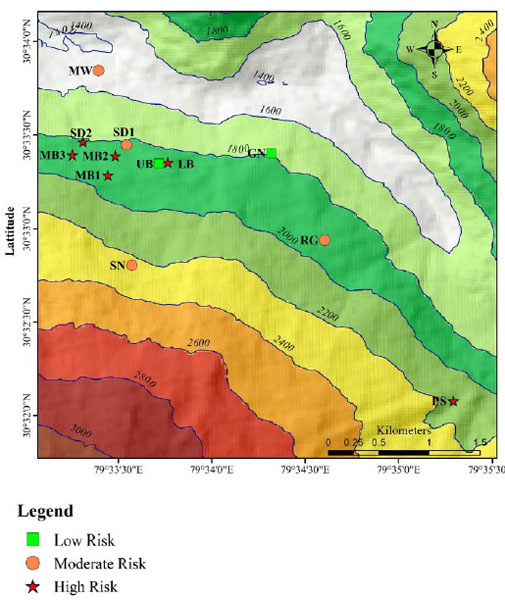
Image credit: IITR
Out of the 12 sites, 6 sites fell in the high risk (HR) zone, leading to the conclusion that 50% of Joshimath lies in a very high risk zone.
Regarding the test site located near main gate of Jaypee Colony in Marwadi:
“From the field test results, the soil is in medium dense condition having good bearing capacity. The damages to the structures would have not resulted from bearing failure of soils, rather due to subsidence of the ground. The subsidence observed here is primarily because of the internal erosion caused by the subsurface seepage as evident from the muddy waters emerging from the damaged retaining wall.”
The bearing capacity of site near Narsingh Mandir in Lower Bazar was found to be very poor, which was well correlated with low soil resistance observed in DCPT testing (DCP-1) at shallow depths. MASW test results indicated the moderate soil stiffness.
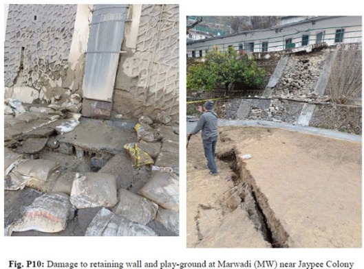
Image credit: IITR
Based on geotechnical investigations and tests, IIT-Roorkee reported that the soil fabric of Joshimath was a complex matrix of boulder supported by gravels and soils.
The main reason for the subsidence appeared to be internal erosion caused by the subsurface drainage, which may be due to infiltration of rain water/melting of ice/waste water discharge from house hold and hotels.
Internal erosion has brought instability to the entire soil fabric and led to readjustment of the boulders which resulted in subsidence.
The report concluded that though subsidence is continuous phenomenon, it can be minimized by controlling infiltration of water, which helps in minimizing the internal erosion.
CGWB
Central Ground Water Board (CGWB) conducted a hydrogeological and geophysical survey and reported that constructions in spring zone or at the emergence point of springs along with seismic activities may be the reason for the land subsidence.
Its study showed that the natural discharge of the earlier existing springs in the area was severely affected. The cessation of spring flow ultimately increases the subsurface pore pressure which result in sudden gush of ground water in form of spring at JP residential premise. The sudden release of ground water reduces the existing pore pressure and the fluctuation in pore pressure results in land subsidence in the area.
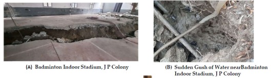
Image credit: CGWB
It also pointed at tectonic discontinuities and burgeoning anthropogenic pressure for the debris laden slope showing prolong northerly movements and causing cracks and tilting of buildings in different pockets of the slope.
NGRI
National Geophysical Research Institute (NGRI) reported that certain areas of Joshimath “sunk vertically by over 3 feet and moved by 1.4 feet” with the fissures on barren and agricultural land as deep as 115 feet and become shallower and tangential at 60-65 feet depth towards lower reaches of the subsidence-hit town”.
In its opinion, it was imperative to understand the type and spatial extent of the ground deformation or subsidence before embarking on detailed mapping of ground fissure and geophysical characterization of shallow sub-surface beds.
Ground Subsidence (Satellite-based SAR-Interferometry)
It carried out the Synthetic Aperture Radar (SAR) interferometry for the spatial and temporal characterization of ground subsidence using Sentinel satellite data, which has an open source data with fortnightly repeat interval.
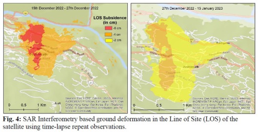
Image credit: NGRI
The map for the 15 December 2022 – 15 January 2023 period shows that the subsidence phenomenon started during start of December 2022 and continued during January 2023. The negative values indicate the LOS subsidence i.e. velocity moving away from the sensor, during the period of recurrent observations.
The subsidence values are > 4-6cm between 15-27 December 2022, and they reduced to 2-4cm by 15 January 2023. There was no subsidence observed at the end of January 2023.
The subsidence is prominent towards the western slope with the peak subsidence in NNW-SSE trending narrow zone. Several small rivulets with minor surface runoff disappeared during the subsidence.
Rapid increase in built-up area…
The land-cover analysis of satellite data reveals that percentage of built-area footprint increased from 1.25 sq.km to 2.5 sq.km from 2010 to 2022. Such a rapid growth in built-up area will obviously inflict tremendous pressure and cause an imbalance in demand and supply chain of water potential, increase large scale build-up of sanitation pits and interrupt the steady-state groundwater recharge scenarios.
Ground Fissure Mapping
A detailed mapping of the fissures was carried out in the town.
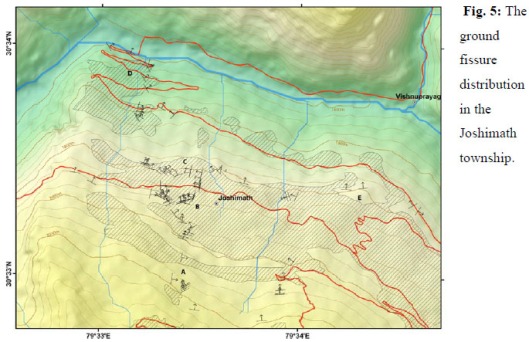
Image credit: NGRI
The fissures are distributed from the upper slopes at ~2200m in Sunil region to the Marwari-JP region at the toe of the Joshimath slope at ~1400m with the map pattern showing a clear localization along the identified subsidence zones.
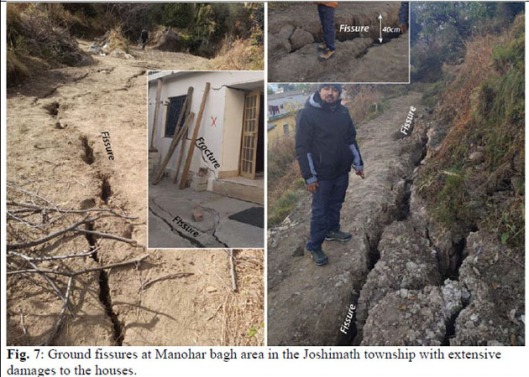
Image credit: NGRI
The fissures are mapped in barren/agriculture fields, roads, building floors, etc. They show characteristic displacement; viz the vertical displacement is prominent towards lower reaches, whereas the horizontal displacement is pronounced in the upper and mid reaches of the subsidence zone.
Multi-proxy Geophysical Characterization of Shallow Subsurface Substrate
In view of high relative relief and strongly sloping rugged terrain of Joshimath, the NGRI team used Electric-vector resistivity survey (EVRI), Multichannel Analysis of Shear Waves (MASW) and Ground Penetration Radar (GPR) techniques for shallow subsurface exploration with specific objectives.
Electric-vector resistivity (EVRI) survey:
The Electric Vector Resistivity (EVRI) survey along ~1km long profiles with >200m depth coverage was for finding depth and geometry of overburden regolith with the basement across the subsidence affected areas.
It revealed concave regolith cover with variable thickness, mostly exceeding >50 m adjacent to the streams or rivulets on the slope and around Manohar Bagh and Narsingh Temple areas.
The high resistivity basement rocks also have narrow zones of fracture where the ground water is channelized, especially towards the toe region.
The fissures are mostly observed in the zones with thick regolith cover; however, the margin areas are also affected by subsidence fissures.
Multichannel Analysis of Surface Waves (MASW) Studies:
The MASW (>50m) study was for determining the subsurface soil characteristics in ~50m regolith section in the subsidence zone.
The shear wave velocity of 12 profiles in and around the subsidence area reveals irregular multi-layered stratification (or arrangement of different layers of soil) is observed in the overburden regolith cover throughout the subsidence zone.
The regolith cover shows low and higher velocity (indicating stiffness of layers) stratification with variable bed thickness.
 Images credit: NGRI
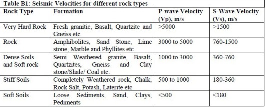
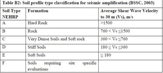
The shear wave velocity (Vs) of the soil layers varies from <360 to >760 m/s up to a depth to 50 m. The top 5-10m low velocity layer is soft-stiff soil with Vs<360m/s, followed by 10-20m thick stiff-dense soil with a thin underlying soft-stiff soil layer, over the basement of consolidated-hard rock formation with a velocity of >760m/s.
The discrete low velocity layer (<360 m/s) of stiff soil derived from old landslide debris material is more prominent at Marwadi, Narsingh Mandir, Auli and Ropeway areas.
The distribution of this low velocity layer should be considered for safety measures, though the beds are not prone to liquefaction (transformation of a granular material from solid to a liquid state because of increased pore water pressure that reduces effective stress). The occurrence of liquefaction depends upon the amplitude and duration of the ground shaking and the depth of the water table. In general, older soils have a lower liquefaction potential. Soils at depths of more than 15m generally do not liquefy due to the high effective confining pressure.
Ground Penetration Radar (GPR) survey:
The Ground Penetrating Radar (GPR) survey was employed to map subsurface geometry and extent of fissures, and the saturation characteristics of the top soil up to a depth of ~30-40m.
It confirmed the stratification with the second higher density layer, which preserves the soil moisture, whereas the low velocity sediments are devoid of saturation. The steep, air filled fissures are extensively developed and extends to a depth >30m. The fissures become gentler and shallower in the saturated slope at the toe of Joshimath, where the ephemeral sediment-rich discharge was observed slope during subsidence.
NGRI modelled this flow accumulation pattern of the Joshimath slope using SRTM DEM of 30m spatial resolution…
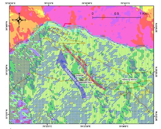
Image credit: NGRI
The direction of subsidence and the subsurface runoff is observed at Marwari towards NW direction. Singdhar acts as barrier to the NE-N directed surface flow of the slope and helps in channelizing it in the north-west direction, which is observed as the ephemeral silt-rich discharge during subsidence.
The InSAR based subsidence map and fissure pattern map also suggest the northwesterly subsidence bordered by Singdhar. The enhanced transient flow at Marwari was observed during 20-22 January 2023 spell of snow and precipitation on Joshimath slope. The disappearance of N-NE flowing rivulets in the upper slopes produced enhanced transient discharge at Marwari during subsidence suggesting a northwesterly subsurface flow.
The subsidence affected slope (A, B, C, D zones) are disjointed small catchments having distinct flow pattern and are bordered by the Singhdar, which seems to control channelization of the surface runoff along the rivulets and possibly subsurface flow as well.
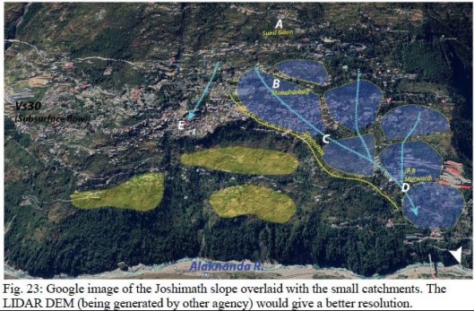
Image credit: NGRI
The slope and aspects map of the region clearly suggests that the Singhdar acts as an obstruction to the N-NNE directed surface runoff.
In NGRI’s opinion, Joshimath 2023 subsidence is a dewatering phenomenon, which is continuing.
Based on combined analysis, it defined two risk zones for the 2023 subsidence, considering the boundary defined by InSAR subsidence and the field observations as limits of the risk zones.
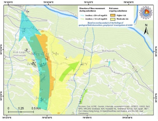
Image credit: NGRI
High risk zone (marked in orange color overlaid with blue arrow) is the peak subsidence zone with numerous fissures, which is affected by a deeper subsurface dewatering flow involving >30m of regolith thickness.
The >30 m deep fissures in the upper slope region of Joshimath channelize disappearing surface runoff to the NW directed subsurface flow, as was observed during subsidence.
Moderate risk zone comprises other areas (marked in yellow) with moderate subsidence without ubiquitous development of fissures, where the subsurface flow is similar to the surface runoff and it affects <15 m of regolith cover.
National Disaster Management Authority (NDMA) Assessment
The National Disaster Management Authority (NDMA) confirmed the observations made by the eight institutions in its report “Post Disaster Needs Assessment. Joshimath Landslide and Subsidence Crisis – 2023”.
The report assessed the damage caused by the land subsidence issue in Joshimath and identified the assistance required for the long-term recovery and reconstruction of the affected sectors.
It provides sector-wise damage assessment figures for housing and resettlement, civic amenities including health and education, drinking water and sanitation, local-level infrastructure such as roads and bridges, disaster risk reduction, and recovery and reconstruction plans.
Here’s a brief summary of key areas impacted by the land subsidence – buildings, roads, water supply, drainage, sanitation and power.
Buildings
According to a bulletin reported by the district administration in April 2023, 868 houses in Joshimath were identified as having cracks, and 181 houses were marked as unsafe for living. In response to the disaster, the government demolished two hotels with major cracks, a Public Works Department (PWD) guest house, and three individual houses. Some individuals voluntarily undertook the demolition of their houses due to the risk. The bulletin further reported that 357 households were evacuated, and 132 families comprising 502 people were living in temporary accommodation, while 167 people moved out of the city and were living in rented accommodation.
The modified risk map is a micro-zonation map improved upon the first level risk map produced by CSIR-CBRI based on the building damage scenario of the area.
![]()
Image credit: NDMA
It is based on the integration of surface damage scenario and subsurface ground conditions as envisaged from different studies.
Road safety
The immediate recovery for the roads include short-term interventions, such as clearing of road surfaces, rectification of surface damages (by chip sealing and patching). Medium-term interventions include rebuilding structures – i.e. culverts, drains and retaining walls, and the protection of embankments and slopes.
In the long run there is a need to build resilience by introducing climate friendly and multi- hazard resilient road designs and construction practices with an adequate system of catch water drainage, retaining walls, and an institutional mechanism for regular monitoring and repair works.
Water drainage
The town is drained by 6 main “Nalas” which are in a poor state of maintenance. Only 48% of the 17854 m of Nala is lined and that too in many places is dilapidated, encroached and unscientific in its design and its ability to carry peak discharge away from the town into the rivers downstream.
Further, the excess run-off as storm water drainage and excess precipitation collected in the town’s catchment must be drained into the existing Nala. For this, there is a need to collect and convey the excess discharges along the road into the Nala with minimum seepage into the ground.
Water supply
Since 1976, the town has an intermittent piped water supply scheme catering to the drinking water and homestead irrigation needs of the people.
Today, a 34.90 km pipe network provides water at 70 LPCD to 3898 households through 1086 domestic and 149 non domestic connections. The network sources freshwater by tapping into 14 springs in the upper catchment of Joshimath and Auli.
As a consequence of increased stress on the natural springs in the region and due to poor management of the catchment upstream, locals have observed a significant reduction in the spring discharge during lean seasons.
The drying springs are met with a 48 year old rusty and difficult-to-plug leaky network that contributes to 40-50% wastage and seepage in Joshimath, thereby contributing to the subsurface moisture which may aggravate the subsidence crisis.
Therefore, to sustainably provide for water supply services, the piped supply system requires network and source augmentation efforts to provide for 135 LPCD. It is recommended to replace old pipelines that run parallel to the existing distribution network which had a multiplier effect on service disruption and infrastructure damage reducing the resilience of the piped network.
The vertical movement in the land mass across the contours as a result of the subsidence in January 2023 caused shearing induced damages in the conveyance system carrying fresh and used water across the town. This resulted in damaged pipes, cracked clear water storages and crushed sewage mains in areas that witnessed substantial mass movement.
The limited ductility of GI pipes used for providing water supply in the town can only handle a limited degree of slope creep over a period of time but land subsidence over an shorter time frame damaged the supply network and hindered availability of safe drinking water for households residing in the subsidence zone particularly in the wards of Sunil, Manoharbagh, Singdhar, Gandhinagar and Marwadi. Being a gravity fed supply system, damages in the upper reaches of the network resulted in supply disruption for almost all the households.
Sanitation
As an outcome of land subsidence, the water supply pipelines which were once underground have been unearthed and are exposed to possible biological contamination. Plugging leakages into the subsurface from the water supply and sanitation infrastructures present in the town is one of the most critical interventions needed to enhance disaster resilience in Joshimath
In the medium term, there is a need to connect all households with a sewage treatment facility. This will help reduce the seepage through soak pits and reduce the quantum of discharge through open drains to allow sufficient carrying capacity for peak discharge.
The existing 14.94 km long sewage main line does not cover Parsari and Ravigram wards. It is recommended to develop a city sanitation plan for Joshimath that includes decentralised sewage treatment facilities for wards and houses which cannot be currently serviced by the existing main line of 14.94 km.
Power
The disaster impact on power sector was not very high. Although it tilted 31 transmission poles and damaged transmission lines and transformers. Electricity supply was snapped for 4-5 days as 11kv power supply lines got damaged. Power generation units were unaffected.
Infrastructure Hazards
Experts and environmentalists have been voicing their disapproval of major infrastructure projects in the region with concerns that these may cause more landslides because of their close proximity to the MCT fault.
The rapid rise in construction activities in Joshimath has been blamed on the widening of NH-7, which runs through the town and carries pilgrims to Badrinath and Hemkund. The widening of the road not only led to increasing number of hotels springing up in and around the town, but also led to increased cleaning of the hills, making the already ecologically sensitive region highly vulnerable to landslides as the top layer was cleaned for the road construction.
It was proposed to circumvent the circuitous route of the Joshimath town, whose larger part is situated on the subsidence zone. To that effect, Border Roads Organization (BRO)’s Helang- Marwadi Bye-pass road is being constructed on the alignment of a previous light-vehicle road, which was operational a few years ago.
This will reduce the dynamic load in Joshimath which sees heavy traffic jams on the highway during the peak season of Badrinath and Hemkund Sahib pilgrimage. Moreover, it will also reduce the length of the highway by 21 km.
Since the major part of the road will pass through the stable rock mass zone, it has been recommended to expedite the road construction to decongest Joshimath town.
In 2017, Prime Minister Narendra Modi launched a 12,000-crore Char Dham All Weather Highway Development Project to improve the existing condition of highways in Uttarakhand for an easy and comfortable journey to the Char Dham and Hemkund Sahib shrines. The Char Dham pilgrimage is the backbone for state tourism and economy.
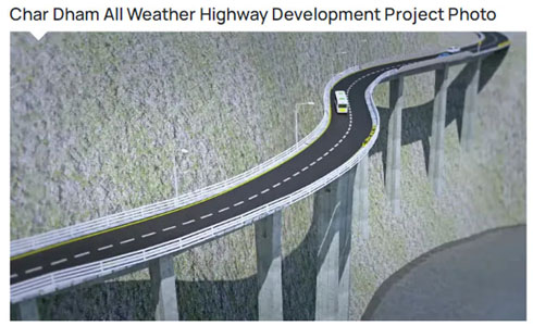
Image credit: https://www.euttaranchal.com/uttarakhand/char-dham-project.php
The National Highways connecting Chardham viz. Yamunotri, Gangotri, Kedarnath and Badrinath including Tanakpur to Pithoragarh section of Kailash- Mansarovar yatra…
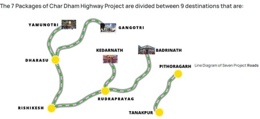
Image credit: https://www.euttaranchal.com/uttarakhand/char-dham-project.php
The 125 km Rishikesh-Karnaprayag Railway line is another major infrastructure project that started in 2019. The rail project consists approximately 80% of tunnels and will connect important towns like Devprayag, Srinagar, Rudraprayag, Gauchar and Karnaprayag through five districts of Uttarakhand, i.e. Dehradun, Tehri Garhwal, Pauri Garhwal, Rudraprayag and Chamoli. Till date, it is ahead with almost 50% completion. Besides facilitating easy access to pilgrimage centres in Uttarakhand, it is aimed at connecting new trade centres, developing backward areas and serving the local population.
There are fears that all these heavy infrastructure projects will exacerbate the fragile situation in the Himalayas where several towns are built atop debris.
The 2023 land subsidence serves as a stark reminder of the delicate equilibrium that must be maintained in ecologically sensitive regions, where human activities interact intimately with the forces of nature. Through careful planning, sustainable practices, and collective responsibility we can protect and rejuvenate this sacred town and other vulnerable areas like it across the Himalayan landscape.
Construction projects must meet safety, structural, and environmental standards. Blasting activities lead to potential hazards like ground vibrations, which can damage nearby structures or ecosystems.
Conclusion
Joshimath does not have adequate public toilets, sewerage systems, waste management systems and parking facilities for vehicles, thus creating traffic jams for the daily influx of 25,000 tourists transiting Joshimath during the peak season. Moreover, the local administration would be hard pressed to make water available to the local residents and visitors.
Since Joshimath is not just of religious, cultural and tourist importance but also of strategic importance, its stability is of vital importance. Hence there is a strong need to decongest Joshimath and reduce the tourist influx beyond carrying capacity by identification and promotion of other accommodation locations in the region.
Coming next: WHY IS MY JOSHIMATH SINKING? – Part 2
Sources:
https://usdma.uk.gov.in/PDFFiles/CBRI.pdf
https://usdma.uk.gov.in/IEC/josimath-reports-1395.aspx
https://covid19usdma.uk.gov.in/PDFFiles/PDNA_NDMA.pdf
https://usdma.uk.gov.in/PDFFiles/CGWB.pdf
https://usdma.uk.gov.in/PDFFiles/GSI.pdf
https://usdma.uk.gov.in/PDFFiles/IIRS.pdf
https://usdma.uk.gov.in/PDFFiles/IITR.pdf
https://usdma.uk.gov.in/PDFFiles/NGRI.pdf
https://usdma.uk.gov.in/PDFFiles/NIH.pdf
https://usdma.uk.gov.in/PDFFiles/Wadia.pdf
https://dmmc.uk.gov.in/files/pdf/Current_Science_Joshimath.pdf
https://sandrp.in/2021/02/20/tapovan-vishnugad-hpp-delays-damages-and-destructions
https://www.euttaranchal.com/uttarakhand/char-dham-project.php
https://www.himalayanclub.org/hj/66/9/geologic-formation-of-the-himalaya
I hope you all are sharing my blog posts with friends and family. To make it more easier for you, tap this link A List Of All My Posts to check out the entire list of my posts 😀 You know, I’d hate to think that you missed something 😉
If you’re my first-time reader, don’t forget to follow my blog 🙂 Enter your email address and hit the “Follow” button and you will receive my new posts by email 🙂
You can read my travel experiences and learn more about the many beautiful destinations in Mexico in my ebook (PDF format):

CLICK Discovering Mexico US$ 16.97 (or the equivalent value in your currency)
HERE TO BUY: https://www.e-junkie.com/i/p6sy
To know all about Mexico, here’s my ebook (PDF format):

Mexico: The Country, Its History & The Maya World US$ 7.97 (or the equivalent value in your currency)
CLICK HERE TO BUY: https://www.e-junkie.com/i/p6vh
For Mexico’s food history, detailed information on Mexican food & drink and a few recipes, buy my ebook (PDF format):

A Guide To Mexican Cuisine US$ 5.97 (or the equivalent value in your currency)
CLICK HERE TO BUY: https://www.e-junkie.com/i/p6vr
If you love reading romance novels and are a big fan of Mills & Boon novels, you will love my romance ebook (PDF format):

The Blue-Eyed Prince of Natlife US$ 4.99 (or the equivalent value in your currency)
If you are a first-time visitor, I hope to see you again soon. Perhaps you might want to leave a like, comment, follow or hopefully all the three 😀
Remember, your feedback is highly appreciated. Your “Like” and comments are greatly valued. And let me tell you that I just love reading the warm words of appreciation that I receive for my work from my readers through the Contact Me Page 😀 So be generous with the feedback 😀
You can also connect with me on:
X (Twitter): https://twitter.com/swarupa007
YouTube: https://www.youtube.com/user/swarupa7
Thanks for stopping by, I hope to see you back 😀 Till then, take care… cheers 😀
